

- 16.01.2022
- Posted by: admin
- Categories: NEWS, Сведение о Таджикистане
Tajikistan is a country of mountains. 93% of the Republic is more than 1,000 meters above sea level, which belongs to the highest mountain systems of Pamir and Tien Shan. Pamir means the Roof of the World, and “Tien Shan” as the Heavenly Mountains. The highest Peak of Tajikistan is the Ismoil Somoni, a height of 7495 meters.
The lowest point of Tajikistan is in the north of the country, at an altitude of 300 meters above sea level. 7% of the Republic is flat in the northwestern and southwestern extremities of Tajikistan and is mainly occupied by agriculture.
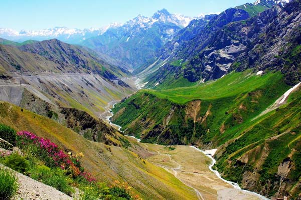
Mountains of Tajikistan
Almost the entire territory of Tajikistan, or rather 93% of the total area, is located in the mountains. Half of the entire country lies at an altitude of more than 3000 meters above sea level. In Tajikistan, there are such mountain systems as the Turkestan, Zeravshan, Gissar, and Alay ranges, and the entire eastern part of the country is located within the Pamir. The highest point of Tajikistan is the Ismoil Somoni peak with a height of 7495 meters. Тhere are 24 peaks above 6000 meters
The mountains of Tajikistan are very diverse. They vary in types of geological rocks, topography, glaciation, and other characteristics. The most beautiful mountains are in the west of the country – there are pointed peaks, wide gorges, juniper forests, alpine meadows, and this part of the country is known to many as the Fann Mountains. The Pamirs are also beautiful and varied but have a harsher climate, higher ridges, and desert plateaus.
Muminabad, is the Childukhtaron (Forty Girls)
250 kilometers south of Dushanbe, near Muminabad, is the Childukhtaron (Forty Girls) mountain complex.
Legend has it that this area has always been famous for its wealth and fertility. Such abundance constantly attracted the attention of belligerent neighbors, who repeatedly tried to penetrate the valley surrounded by mountains to enslave residents, but time after time they were repulsed
One day, the formidable Genghis Khan turned his eyes on this tidbit and sent his troops to subdue the mountainous region. All the men of the valley stood up to defend their native land, but the forces were not equal. And when the warriors of the gorge fell in a fierce battle, their place was taken by forty young maidens in men’s clothes.
Fann Mountains (Fani)
Fann Mountains (Fani) – amazingly beautiful land of mountain lakes and snow-capped peaks, located in Central Asia (on the territory of Tajikistan), at the junction of two huge ridges of the Pamir-Alai – Zaravshan and Hissar, near the famous ancient city of excursions – Samarkand. This is a truly unique mountainous country, whose ancient name sounds like Kuhistan (translated from Farsi as “Land of mountains”).
Picturesque gorges and passes, wild rivers, ancient glaciers and magnificent emerald green and turquoise lakes, juniper forests and pointed peaks, stable warm weather and convenient transport accessibility make this mountain area extremely attractive to climbers, tourists and fans of extreme sports.
The highest point of the Fann Mountains is the Chimtarga peak (5,494 m). To the south of Chimtarga in the Zaravshan range rises the peak of Energy (5100 m). From the north with Chimtarga neighbors Mirali (5200 m). In the northern spur are remarkable peaks – Bodkhona (5300 m) and Chapdara (5200 m), in the south – the peaks of Red Dawn and White Bars.
In the Eastern Fann Range are located sequentially, starting from Energy, summits: four-thousandths peaks – Snake (4150 m), Physical Culture and Sport (4120 m), Gratuleta (4230 m), Chinal with Fagitar spur (4277 m), Payhamber (4958 m); five-thousands peaks – Castle (5070 m), Black peak (5010 m), Little Hanza (5031 m), Big Hanza (5306 m); four-thousands peaks – Fan Ullah, Sarof, Ships, Zinnakh, Shome.
From the node peak Sarof to the north and south depart spurs: north – Turzulsk with Stupenka (4200 m), Tower, Patrush (4040 m) and Tangi, south – a short spur with a summit-four-thousandth Fingers (4150 m)
In the Western Fansky Range are the peaks: Maria (4,800 m), Aurondag (4,600 m), Saryshah (4,700 m), and Ghaznych (4,200 m). In the Zaravshan Range to the south of Mt. Energy there are peaks: Rock Wall (4734 m), Moscow (5200 m), Sugar Head (about 5000 m), Pushnovat (4600 m), and further the range turns to the west and forms a powerful rock-ice barrier Dukdon with peaks up to 5000 m.
Pamir Mountains
The Pamir Mountains, the greatest, mysterious, lost in the wilds of Asia, have always stirred the mind. Sharp peaks seemed unattainable, deep stony gorges seemed inaccessible, winding roads going into the clouds seemed unreliable. Rising to the sky, the mountain peaks remember the Persian kings, mysterious Bactria and the troops of Alexander the Great, the path of Tamerlane and Bobur, Marco Polo and dozens of pioneering explorers of glaciers and mountains passed here. Caravans carried Chinese silk, lapis lazuli and rubies from local mines along the roads above the abyss. Today we know much more about Pamir, but we can’t stop marveling at its beauty and diversity. Here every tourist awakens the spirit of adventurism
Before the extensive development of the Himalayas, the Pamirs were referred to as the “roof of the world. It is surrounded by a tight ring of the giant mountains of Asia: the Himalayas, Karakoram, Hindu Kush, Hissaro Alai, Tien Shan and Kunlun. The Pamir Mountains are shared by Tajikistan, Kyrgyzstan, China, Pakistan and Afghanistan. And everywhere they appear to travelers different, but invariably fascinating
The most famous points of Pamir are the Somoni (Communism) Peak – 7,495 m, Independence (Lenin) Peak – 7,134 m, Korzhenevskaya Peak – 7,105 m and the world’s largest valley-type glacier – the Fedchenko Glacier. In addition, you can see a lot of mountains above 6,000 meters.
Lakes in Tajikistan
Lakes in Tajikistan are as much an integral part of the country’s nature as mountains. They occupy only 1% of the territory of the country, but their number exceeds 2,000. Most of these “pearls” are scattered in the mountains of Tajikistan, and are located in picturesque gorges. Therefore, they are mostly of the rubble type origin, when rock fell from the mountains, creating natural dams.
Lake Iskanderkul
Lake Iskanderkul is one of the visiting cards of Tajikistan. To visit Tajikistan, but not to go to Lake Iskandarkul, is like visiting Paris for the first time, but not to climb the Eiffel Tower. Moreover, getting to this popular attraction is not so difficult – there are only 130 km from Dushanbe to Iskandarkul Lake.
The name of the lake Iskandarkul comes from “Iskandar” – this is how Alexander the Great was called in the East, and “kul” – which means lake in Turkic languages. That is, this is the lake of Alexander the Great. It is not known for certain whether the famous commander has been here, but several legends about the lake are associated with his name.
According to one legend, during a campaign against Sogdiana and Bactria, Alexander the Great met resistance from one mountain village, which resolutely did not want to submit to the great conqueror. And then Alexander ordered to change the river beds in order to flood the recalcitrant, and this is how Lake Iskandarkul was formed.
According to another legend, in time from his conquests, Alexander the Great stopped for a halt on the shore of the lake, and his beloved horse Bucephalus caught a cold after drinking the icy water of Iskandarkul. When he recovered, he climbed a high rock and threw himself into the water. Alexander waited several days, and leaving the grooms by the lake, he took his army away. And since then, on the full moon on Iskandarkul, you can see a snow-white horse that comes out of the water to graze on the picturesque coast.
If you look at Iskandarkul from a scientific point of view, then this is a dammed lake, which was formed after a rock collapse. It is located at an altitude of 2195 meters above the level, reaches a depth of 72 meters, and has an area of 3.4 km². You can swim in it, and many tourists rest on rocky beaches in summer, but already 10 meters from the coast, the water temperature drops sharply to about + 10 ° C.
For the sake of Iskandarkul it is worth spending a day on a trip here from Dushanbe, and the memories of this beautiful lake will last a lifetime!
Lake Karakul
In the highest part of the Pamir highway, at an altitude of 3,914 meters is Lake Karakul, whose name is translated as “Black Lake”. The Pamir highway passes a few hundred meters from the coast of this natural landmark, and you can admire it for 40 km. Also, the village Karakul of the same name is located here, which stands out for its rugged appearance.
Lake Karakul has an area of 380 km2, from north to south has a length of 33 km, and from east to west 24 km. In the middle there is a huge island that divides Karakul into two parts: the eastern part is 22 meters deep and has smooth slopes to the water; the western part is more abrupt and here the depth reaches 236 meters. Although this drainless lake is fed by glaciers from the surrounding mountains, the water in Karakul is salty. The water temperature is 12 degrees Celsius in summer and closer to zero in winter, and is covered with ice up to 1 meter thick.
The beauty of Karakul Lake is achieved not only by its bright blue color, but also by the picturesque landscape, which is reflected in the water by the snow-white peaks of the Pamir. Around the lake there is a series of seven-thousands, among which Lenin Peak and Avicenna Peak stand out. And also, due to the high altitude, the sky seems closer, and differs in deeper color, and at night the Milky Way shines brightly over the lake.
Sarez Lake
Sarez Lake is located in the Pamirs, in the Murghab region of the Gorno-Badakhshan Autonomous Region of Tajikistan. The length of the lake is about 55.8 km, the depth is about 500 m, the water edge is about 3263 m above sea level, the volume of water is more than 16 km3. The surrounding mountains rise more than 2,416 m above the lake.
Lake Sarez belongs to the so-called dammed, or dammed, lakes that have arisen as a result of the catastrophic blockage of the Bartang River (Usoy Dam). The blockage was formed on February 18, 1911 at about 23 hours 15 minutes Tashkent time after a strong earthquake (9 points), when the Murgab river was dammed up as a result of a strong landslide at the front about 4.5 km, burying the village of Usoy and resting on the opposite side of the valley. At the same time, the rocks formed a natural dam with a height of 567 m
The northern part of the dam is the least high, composed of dolomite, gypsum and marble fragments. Part of the dam is a ridge stretching from northeast to southwest and composed of siliceous and clayey shales. The western part consists of fine debris.
Alaudinsky lakes
Alaudinsky lakes (Chapdara), lying at an altitude of 2800 m, are considered one of the most beautiful lakes in the Fan Mountains. They belong to the Pasrud river system. It is one day’s journey from the village of Pasrud. From the mouth of the Chapdara, a good path goes up this river. In the distance, peaks open: the stone pillar of Adamtash peak (4580 m), the strict Mirali cone (5106 m) and in the distance – Maria peak (4790 m), on the left above the forest, the Chapdar peak rises.
Here in the gorge, at an altitude of 2635 m, there is a popular mountaineering camp “Vertical-Alaudin”. Another 1.5 km along a good path up the gorge, and the traveler finds himself on the legendary Alaudins. When viewed from a height, mountain lakes are always blue or light blue. Their color is borrowed from the sky. But the color of the Alaudin lakes is born inside and wins in a dispute with the sky. Sixteen and a half meters deep, and not a single grain of sand suspended in the water. A five-kilometer underground stone filter reliably protects the purity of the lake. They cannot muddy its underwater springs, beating under the southern coast, and the noisy stream that rushed into the lake, bursting out from under the colossal stone plume of Chapdara, is crystal clear
The trail runs along the western shore of the Big Alaudin Lake. Here, in the southwest corner, there is a green lawn where it is convenient to put up tents. On the other side of the lake, a peninsula juts out into the lake with a curved stone hook. A river emerges from the Big Lake, further dividing. One branch flows into the Middle Lake, and the other disappears into the heaps of moraine, so that later it can break out in effervescent ribbons below the green slope above the Lower Lake.
Lake Yashilkul
Yashilkul means “green lake”. It is located at the height of 3700 m above sea level, its length is about 19 km, width is from 1 to 4 km, depth is up to 50 m, water temperature is never higher than +14 degrees Celsius. The water is clean and transparent, through its thickness you can see the flocks of fish (there is a frogman nagorets) in shallow water and shoots of algae between the rocks. Among thecosmic wildness of the Pamir mountains, such peculiar places as Lake Yashilkul are rare.
The lake was formed as a result of a blockage that blocked the Alichur River. The length of the blockage is more than 4 km, and it is 100-110 meters thick. Water overflows over the southern edge of the rubble, and it is from here that the Gunt River originates, which after 200 km flows into the Panj River. There is an old trail on the rubble, next to which geologists found a granite block with inscriptions in Arabic informing about those who paved the way here in ancient times/
At the mouth of the Alichur River, the area is swampy, with a lot of sedges. The shallowest, eastern part of Yashilkul is located here. The place where the river flows into the lake stands out as a bright green spot. Near the mouth of the Alichur is a hot sulfurous spring Issyk-bulak. Its water gushes out of four griffins located along the foothills of a granite massif and reaches a temperature of 71 degrees Celsius. The spring is surrounded by half-destroyed clay structures (probably mazars or mausoleums) and is considered “holy” by the locals. A small clay structure has a pool to collect water from the hot spring.
On the north side of the lake, steep granite cliffs approach almost to the water, leaving only a narrow strip of shore a few meters wide. If you walk along the northern shore, you can reach the rockfall that forms the lake. Car tracks from the north lead only to the confluence of the Big Marjan River into the lake, and further, to the rubble, there is only a footpath. To get to the northern shore of Yashilkul, you have to go over the shallow Alichur River at its inflow into the lake.
There are many legends and myths connected with the lake. The most ancient of them is a legend about a huge animal called Tyuya-su (water camel) by local Kyrgyz who lives in the lake.
HAFTKUL (Seven lakes Seven Diamonds of the Fann Mountains)
In the west of Tajikistan, near the town of Panjakent, there is a beautiful natural complex Seven Lakes, which amazes everyone with its rich and constantly changing color of water. It is also known as Haftkul, which is translated from Tajik as Seven Lakes. Sometimes there is a toponym Marguzor Lakes, which comes from the name of the largest lake. Each lake has its own name: the lowest and the first lake, which usually begins the acquaintance, Nezhigon, then Soya, Gushor, Nofin, Khurdak, the largest Marguzor, and the last Hazorchashma.
Seven lakes are located in the Fann Mountains, in the gorge of the Shing River. The lowest one is located at an altitude of 1,640 meters above sea level, and the last one at 2,400 meters. Total height difference is 760 meters and the distance between the lakes is more than 14 kilometers, but do not worry, there is an unpaved highway through all seven lakes and the ascent by serpentines, excluding stops, will take no more than an hour. All the lakes, except the last one, Hazorchashma, belong to the rubble type of lakes, and appeared due to the descent of rocks in a narrow gorge. Ancient petroglyphs found on the shores of one of them indicate that the lakes are quite old.
Nezhigon (Nezhegon, Nezhigok, Mizhgon)
The first lake seen by travelers. Its unusual name is translated from Tajik as “eyelashes,” although no signs hint at the origin of such a name. There are also variations of the name – Nezhegon, Nezhigok, Mizhgon. The height of the lake is 1,640 meters above sea level, the depth is up to 20 meters, and the area is 0.05 sq km.
The water in Nezhigon stands out with a palette of colors: depending on the light and time of year, it can be turquoise, blue and even purple. This is due to the strong mineralization of water with sodium and calcium. In summer, the water is quite warm and you can take a dip in this mesmerizing lake.
SOYA
After climbing a steep serpentine road and looking back at Nezhigon, travelers will find themselves right at the shore of the second lake, Soya. This toponym is translated from Tajik as “shadow,” and this name is explained by the fact that the lake is located between high cliffs, and almost all day its waters are in shadow
The water in Soya is similar to the water in Nezhigon, it also changes its color depending on the weather and time of day. The lake is 1701 meters above sea level, and the water surface area is 0.1 square km.
GUSHOR
Lake Gushor is located 400 meters from Soya, and as you go up to it, you can see the turbulent stream connecting them. Gushor Lake is located at an altitude of 1771 meters above sea level, and its area is 0.23 square kilometers.
There are consonant names of this lake – Khushyor, Izshor, and they all mean “watchful”. It is surrounded by steep cliffs, and there used to be poisonous snakes, which explains the origin of the name.
NOFIN
The distance from Lake Gushor to Lake Nofin is only 400 meters, but the ascent through the serpentine is a kilometer. The fourth of the seven lakes has a very elongated shape and its length exceeds 2.5 km with an average width of 200 meters. It is located at an altitude of 1,820 meters above sea level, the water surface area is 0.48 sq km.
The name of Lake Nofin translates as “umbilical” and its origin is attributed to the fact that it is the central of the seven lakes and also very long, resembling an umbilical cord. Locals tell various legends and say that the lake has its secrets. The road runs along the eastern shore and sometimes floods in the summer, so that cars have trouble getting through. At the far end of the lake there is a small village with guest houses.
KHURDAK (baby)
It is the smallest of all seven lakes. Even its name translates as “baby”. Its area is only 0.025 square kilometers, and it is located at an altitude of 1870 meters. The distance from Nofin Lake is 1.5 km and on the way you will see the village of Padrut.
Once upon a time there was a small hydroelectric power station on Khurdak, which provided electricity to the village and the surrounding houses.
MARGUZOR
Its area is 1.16 square kilometers, its length reaches 2.7 km, and the maximum depth is 45 meters. The wide expanse of blue water and the majestic mountains in the background create a magnificent landscape.
It was on the banks of the Marguzor that the petroglyphs of primitive people were found. In the Middle Ages, semi-precious stones were mined near the lake. Today, at the southern end of the lake, there is a small village with houses scattered along the surrounding slopes. Local residents can tell legends and fairy tales in which Lake Marguzor will appear.
The road through the lake goes along the eastern shore, in some places almost at the water level. In case of spills, the lake floods the road and can only be driven by a truck or a reliable jeep. Also, in the southern part of Marguzor, a trail begins leading to the Tavasang pass (3307 meters), from which you can go along one of the mountain routes in the Fan Mountains.
KHAZORCHASHMA
It is located at an elevation of 2,400 meters above sea level. It is as large as Marguzor, but still somewhat inferior in size: the area of the water surface is 0.92 km2, and the maximum length is 2 km. The name Khazorchashma or Azorchashma means “a thousand springs” – it really feeds on the waters of two rivers and many streams.
This is the last lake in the Shing River gorge, and further there are no settlements, the road ends and then only the wild nature of the Fan Mountains. Therefore, you can only look at the lake from the north side. To look from the south side, you will have to go on a mountain hike, bypassing the rocky shores of the lake, but as a reward tourists will get a magnificent view of Khazorchashma, behind which you can see the waters of Marguzor in the distance.